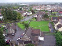
Yate is a town and civil parish in South Gloucestershire, England. It lies just to the southwest of the Cotswold Hills and is 12 miles (19 kilometres) northeast of Bristol city centre and 11 miles (18 kilometres) from the centre of Bath, with regular rail links to both cities.
Developing from a small village into town from the 1950s onwards the 2011 census listed Yate's population as 21,789. The market town of Chipping Sodbury (population 5,045) is contiguous with Yate to the east. In addition, a large southern section of the built-up area spills over into the parish of Dodington (population 8,206), and so the total population of Yate's urban area is now approaching 35,000.
History
The first mention of Yate is the existence of a religious house in about AD 770; Yate is also mentioned in the Domesday Book of 1086. The name is derived from the Old English word giete or gete, meaning 'a gateway into a forest area'.
During the Anglo-Saxon period and well into medieval times, most of this part of south Gloucestershire was covered with forest. Through the centuries the land was cleared for farming.
The town's parish church, St Mary's, dates from Norman times. It was altered during the 15th century and was extensively restored in 1970. St Mary's Primary School, situated outside the churchyard walls, was built on the site of a former poorhouse.
It was the opening of the railway station in 1844, as part of Bristol and Gloucester Railway, that established Yate, with Station Road becoming the central thoroughfare. The cattle and produce markets were held around this road, and businesses were established there. Yate railway station was closed by the Beeching cuts in January 1965, but was reopened in May 1989; the Brunel-built engine shed is preserved nearby.
In the 1960s Yate was designated as a development area and the building boom began. The creation of a new town included a large retail shopping area, sports and leisure development together with public buil
