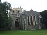
Royston is a town and civil parish in the District of North Hertfordshire and county of Hertfordshire in England.
It is situated on the Greenwich Meridian, which brushes the town's eastern boundary, and at the northernmost apex of the county on the same latitude as towns such as Milton Keynes and Ipswich. It is about 43 miles (69 km) north of central London in a rural area.
Before the boundary changes of the 1890s, the boundary between Hertfordshire and Cambridgeshire ran east–west through the centre of town along the middle of Melbourn Street. The town has a population of 15,781 as of 2011.
History
The town grew at the crossing of two ancient thoroughfares, Ermine Street and the Icknield Way (cum Ashwell Street); the former was created after the Roman conquest, while the Icknield Way has long been accepted as a prehistoric routeway. The roads are sometimes called military roads as they were prepared or improved by Roman soldiers to facilitate access to the hinterland of Roman Britain. The path of Icknield Way is occupied by the present day A505, which bypasses the town to the north. The A10 follows the alignment of Ermine Street south of the town, but diverts before it reaches the crossroads. The A1198, known as the Old North Road follows the alignment of Ermine Street northwards. Barrows on Goffers Knoll and Therfield Heath are evidence of prehistoric settlement.
A cross, variously known as Royse's, Rohesia's, or Roisia's Cross, was erected by the crossroads at an unknown date. It gave the settlement its earliest name of Crux Roesia or Roisia's Cross. By the 14th century this had become Roisia's Town, Roiston or Royston. A large boulder of red millstone grit, bearing a square socket, supposed to be the base of the cross, has been placed by the cross roads at the northern end of High Street.
Until 1540 Royston was divided between five parishes: Barkway, Reed and Therfield in Hertfordshire and Melbourn and Kneesworth in Cambridgeshire. In that year it
